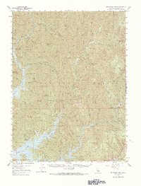
1957 Map of Bollibokka Mtn
USGS Topo · Published 1967About this map
The waters of Shasta Lake dominate this mid-century view of the northern Sacramento Valley, where the McCloud River and Pit River converge. This map documents a transitional landscape within the Shasta National Forest, capturing the post-dam geography where rising waters reached deep into canyons like Squaw Creek. Of significant historical interest is the Bully Hill (Site) and a nearby Cem, indicating the remnants of a mining district that predated the reservoir. Cultural footprints are scattered throughout the mountainous terrain, including the Bollibokka Club and isolated outposts such as Wheeler Ranch. Forestry and management infrastructure is well-defined by the McCloud Bridge Guard Sta, Madrone Guard Sta, and the Squaw Creek Fire Control Sta. The map also traces the Curl Ridge Trail and multiple jeep trails, reflecting the era's reliance on primitive roads for land access in these steep basins.
Find a feature on this map
97 named features on this map. Tap any name to fly to it.
Don’t see what you’re looking for? This feature index may not catch every label — zoom into the map to look around manually.
Map Details
Editions of this 1957 Bollibokka Mtn Map
2 editions found
Other maps of this area

1886 · Lassen Peak
USGS Topo · 1:250,000

1886 · Modoc Lava Bed
USGS Topo · 1:250,000

1886 · Shasta
USGS Topo · 1:250,000

1890 · Red Bluff
USGS Topo · 1:250,000

1892 · Modoc Lava-Bed
USGS Topo · 1:250,000

1892 · Lassen Peak
USGS Topo · 1:250,000

1894 · Lassen Peak
USGS Topo · 1:250,000

1894 · Red Bluff
USGS Topo · 1:250,000

1894 · Shasta
USGS Topo · 1:250,000

1901 · Redding
USGS Topo · 1:125,000