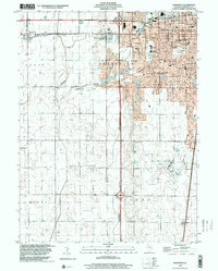
1998 Map of Bondville
USGS Topo · Published 2001About this map
The expanding western edge of Champaign meets the agricultural flatlands of Central Illinois in this detailed topography. The landscape is defined by the transition from urban residential grids to the drainage networks of the Kaskaskia Ditch and Twomile Slough. To the south, the sprawling grounds of the University of Illinois-Willard Airport stand as a major regional landmark, while the village of Bondville and the neighborhood of Kenwood anchor the western and northern sectors.
Find a feature on this map
48 named features on this map. Tap any name to fly to it.
Don’t see what you’re looking for? This feature index may not catch every label — zoom into the map to look around manually.
Map Details
Editions of this 1998 Bondville Map
This is the sole edition of this map. No revisions or reprints were ever made.
Other maps of this area

1906 · Urbana
USGS Topo · 1:62,500

1907 · Mahomet
USGS Topo · 1:62,500

1950 · Tuscola
USGS Topo · 1:62,500

1956 · Villa Grove
USGS Topo · 1:62,500

1957 · Urbana
USGS Topo · 1:62,500

1957 · Urbana
USGS Topo · 1:24,000

1957 · Rising
USGS Topo · 1:24,000

1957 · Mahomet
USGS Topo · 1:62,500

1957 · Bondville
USGS Topo · 1:24,000
1957 · Thomasboro
USGS Topo · 1:24,000