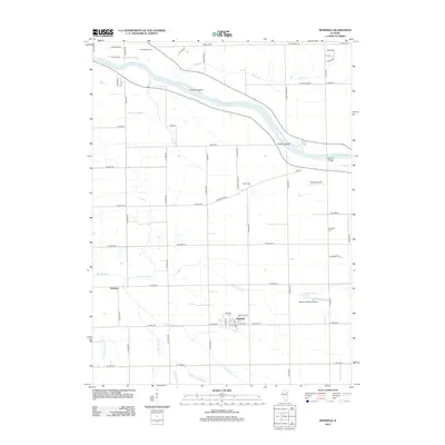
2012 Map of Bonfield
USGS Topo · Published 2012About this map
The Kankakee River winds through the northern portion of this Kankakee County landscape, defining a corridor of riparian terrain marked by Hoffman Island and the Smith Islands. The village of Bonfield serves as the primary settlement, situated south of the river and surrounded by a rectangular grid of rural roads and agricultural plots. This 2012 survey illustrates the persistent rural character of the area, punctuated by small communities such as Frielings and Warner Bridge. Local history and genealogy are well-represented by several family-named burial sites, including Schreffler Cem, Beach Cem, and Wesley Cem, while the Bonfield Cem sits just north of the village center. The map also highlights a distinct aviation presence with two small airfields, Hawker Airport and Classic Landings Airport, integrated into the prairie landscape. Numerous watercourses like Terry Cr and N Bonfield Br drain toward the river, indicating the subtle hydraulic patterns of the region.
Find a feature on this map
66 named features on this map. Tap any name to fly to it.
Don’t see what you’re looking for? This feature index may not catch every label — zoom into the map to look around manually.
Map Details
Editions of this 2012 Bonfield Map
This is the sole edition of this map. No revisions or reprints were ever made.
Other maps of this area

1892 · Wilmington
USGS Topo · 1:62,500

1918 · Wilmington
USGS Topo · 1:62,500

1922 · Kankakee
USGS Topo · 1:62,500

1923 · Herscher
USGS Topo · 1:62,500

1924 · Kankakee
USGS Topo · 1:62,500

1925 · Herscher
USGS Topo · 1:62,500

1949 · Peotone
USGS Topo · 1:62,500

1953 · Wilton Center
USGS Topo · 1:24,000

1953 · Symerton
USGS Topo · 1:24,000

1953 · Chicago
USGS Topo · 1:250,000