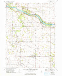
1973 Map of Bonfield
USGS Topo · Published 1975About this map
The Kankakee River defines the northern landscape of this Illinois quadrangle, winding past Hoffman Island and the Smith Islands. Much of this riverfront is preserved within Kankakee River State Park, where Warner Bridge provides a crossing near the border of Will and Kankakee Counties. The interior is marked by a network of drainage, including Rayns Creek and Terry Creek, illustrating the agricultural character of Wesley, Custer, and Salina townships.
Find a feature on this map
27 named features on this map. Tap any name to fly to it.
Don’t see what you’re looking for? This feature index may not catch every label — zoom into the map to look around manually.
Map Details
Editions of this 1973 Bonfield Map
This is the sole edition of this map. No revisions or reprints were ever made.
Other maps of this area

1892 · Wilmington
USGS Topo · 1:62,500

1918 · Wilmington
USGS Topo · 1:62,500

1922 · Kankakee
USGS Topo · 1:62,500

1923 · Herscher
USGS Topo · 1:62,500

1924 · Kankakee
USGS Topo · 1:62,500

1925 · Herscher
USGS Topo · 1:62,500

1949 · Peotone
USGS Topo · 1:62,500

1953 · Wilton Center
USGS Topo · 1:24,000

1953 · Symerton
USGS Topo · 1:24,000

1953 · Chicago
USGS Topo · 1:250,000