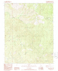
1987 Map of Bonita Meadows
USGS Topo · Published 1987About this map
Sequoia National Forest lands dominate this high-altitude landscape in the southern Sierra Nevada, where administrative and recreational infrastructure centers around the Blackrock Visitor Information Sta (USFS) and the Well Work Center. The area is characterized by a high concentration of montane meadows, such as Bonita Meadows, Danner Meadow, and Paloma Meadows, which suggest a long history of seasonal grazing and water management. To the southeast, the Dome Land Wilderness protects the more primitive reaches of the terrain. The presence of a Radio Heliport and various Borrow Pits reflects the mid-century operational needs of the forest service and resource management. Drainage patterns are defined by the headwaters of Rattlesnake Creek and Beach Creek, which carve through the prominent Beach Ridge.
Find a feature on this map
27 named features on this map. Tap any name to fly to it.
Don’t see what you’re looking for? This feature index may not catch every label — zoom into the map to look around manually.
Map Details
Editions of this 1987 Bonita Meadows Map
3 editions found
Other maps of this area

1905 · Olancha
USGS Topo · 1:125,000

1905 · Fairview
USGS Topo · 1:24,000

1906 · Kernville
USGS Topo · 1:125,000

1907 · Olancha
USGS Topo · 1:125,000

1908 · Kernville
USGS Topo · 1:125,000

1918 · Fairview
USGS Topo · 1:31,680

1948 · Bakersfield
USGS Topo · 1:250,000

1948 · Fresno
USGS Topo · 1:250,000

1955 · Bakersfield
USGS Topo · 1:250,000

1955 · Fresno
USGS Topo · 1:250,000