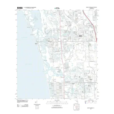
2012 Map of Bonita Springs
USGS Topo · Published 2012About this map
Bonita Springs and its surrounding coastal communities are defined by an intricate network of waterways and residential developments. The Imperial River flows westward through the heart of the region, flanked by neighborhoods like Bonita Shores and Palm River. This 2012 survey illustrates the transition from the Gulf of Mexico beaches of Big Hickory Island and Little Hickory Island to the dense inland grids.
Find a feature on this map
269 named features on this map. Tap any name to fly to it.
Don’t see what you’re looking for? This feature index may not catch every label — zoom into the map to look around manually.
Map Details
Editions of this 2012 Bonita Springs Map
This is the sole edition of this map. No revisions or reprints were ever made.
Other maps of this area

1956 · West Palm Beach
USGS Topo · 1:250,000

1957 · West Palm Beach
USGS Topo · 1:250,000

1958 · West Palm Beach
USGS Topo · 1:250,000

1958 · Bonita Springs
USGS Topo · 1:24,000

1958 · Corkscrew NW
USGS Topo · 1:24,000

1958 · Estero
USGS Topo · 1:24,000

1958 · Belle Meade NW
USGS Topo · 1:24,000

1958 · Corkscrew SW
USGS Topo · 1:24,000
1958 · Fort Myers Beach
USGS Topo · 1:24,000

1958 · Naples North
USGS Topo · 1:24,000