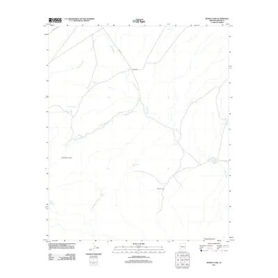
2011 Map of Bonita Tank
USGS Topo · Published 2011About this map
Bonita Creek and its complex network of seasonal drainage channels define this corner of Graham County, providing a vital water lifeline through the arid Arizona landscape. This early 21st-century record reveals the continued importance of ranching and remote outposts, with named sites such as Horse Camp and Slaughter Camp situated near the prominent Slaughter Mountain. The geography is heavily influenced by the movement of water, or the lack thereof, as evidenced by the numerous tanks and catchments like Bonita Tank, Allan Tank, and Mocho Tank. These features reflect a history of land management and livestock sustainment in the region. Transportation is facilitated by tribal infrastructure, specifically Indian Rte 18 and Indian Rte 11, which provide access to the deep cuts of Paymaster Canyon and the winding course of Paymaster Wash as they descend toward the larger creek beds.
Find a feature on this map
20 named features on this map. Tap any name to fly to it.
Don’t see what you’re looking for? This feature index may not catch every label — zoom into the map to look around manually.
Map Details
Editions of this 2011 Bonita Tank Map
This is the sole edition of this map. No revisions or reprints were ever made.
Other maps of this area

1954 · Clifton
USGS Topo · 1:250,000

1957 · Clifton
USGS Topo · 1:250,000

1958 · Clifton
USGS Topo · 1:250,000

1960 · Fort Thomas
USGS Topo · 1:62,500

1962 · Clifton
USGS Topo · 1:250,000

1962 · Bryce Mountain
USGS Topo · 1:62,500
1967 · Point of Pines East
USGS Topo · 1:24,000
1967 · Point of Pines West
USGS Topo · 1:24,000
1967 · Tule Tubs
USGS Topo · 1:24,000
1986 · Clifton
USGS Topo · 1:100,000