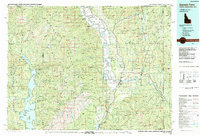
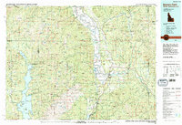
1983 Map of Bonners Ferry
USGS Topo · Published 1983About this map
The Kootenai River snakes through the deep valley of the Purcell Trench, anchoring a landscape where rail lines and river hydrology dictate the pattern of settlement. In this 1983 revision, the region is defined by the proximity of the Canada-United States border, with northern outposts like Porthill and the uniquely named Good Grief marking the edge of the wilderness. To the west, the massive waters of Priest Lake and Upper Priest Lake are surrounded by the Kaniksu National Forest, while the center of the sheet is dominated by the industrial and transport hub at Bonners Ferry. The map documents a rugged extractive economy, showing several high-country operations including the Golden Scepter Mine and Bethlehem Mine. Transportation routes like the Spokane International railroad follow the river's path, connecting the remote hamlets of Naples, Moravia, and Leonia to the broader Pacific Northwest network.
Find a feature on this map
225 named features on this map. Tap any name to fly to it.
Don’t see what you’re looking for? This feature index may not catch every label — zoom into the map to look around manually.
Map Details
Editions of this 1983 Bonners Ferry Map
2 editions found
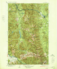
Other maps of this area

1901 · Sandpoint
USGS Topo · 1:125,000

1911 · Priest Lake
USGS Topo · 1:250,000

1911 · Sandpoint
USGS Topo · 1:125,000

1913 · Priest Lake
USGS Topo · 1:250,000

1920 · Libby
USGS Topo · 1:125,000

1930 · Libby
USGS Topo · 1:125,000
1932 · Libby
USGS Topo · 1:125,000

1934 · Metaline
USGS Topo · 1:125,000

1936 · Newport
USGS Topo · 1:96,000

1942 · Metaline
USGS Topo · 1:125,000