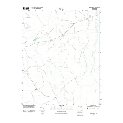
2010 Map of Bonnetsville
USGS Topo · Published 2010About this map
Great Coharie Creek and Little Coharie Creek define the drainage of this coastal plain landscape, where agricultural land is broken by the dense vegetation of Bearskin Swamp. The settlement pattern in this part of Sampson County is characterized by a network of small, established communities such as Bonnetsville, Concord, and Snow Hill. The map traces a history of water management and local industry through features like Halls Pond Dam and Fox Lake Dam, while legacy place names like Old Savanna and Highsmiths reflect long-standing family and geographic identities. Local genealogy is further supported by the presence of Hillcrest Memorial Gardens, located near the northern edge of the survey. The road network, including Concord School Rd and Harmony Church Rd, suggests the historical locations of community centers that once served these rural townships.
Find a feature on this map
55 named features on this map. Tap any name to fly to it.
Don’t see what you’re looking for? This feature index may not catch every label — zoom into the map to look around manually.
Map Details
Editions of this 2010 Bonnetsville Map
This is the sole edition of this map. No revisions or reprints were ever made.
Other maps of this area

1909 · Coharie
USGS Topo · 1:62,500

1953 · Florence
USGS Topo · 1:250,000

1953 · Raleigh
USGS Topo · 1:250,000

1954 · Florence
USGS Topo · 1:250,000

1954 · Raleigh
USGS Topo · 1:250,000

1959 · Roseboro
USGS Topo · 1:62,500

1959 · Garland
USGS Topo · 1:62,500

1974 · Salemburg
USGS Topo · 1:24,000

1982 · Elizabethtown
USGS Topo · 1:100,000
1986 · Ingold
USGS Topo · 1:24,000