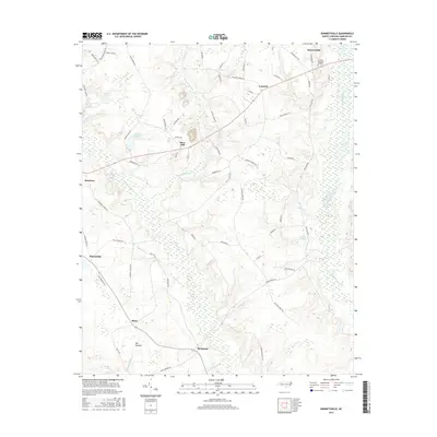
2016 Map of Bonnetsville
USGS Topo · Published 2016About this map
Bonnetsville and the surrounding coastal plain of Sampson County are defined by a network of slow-moving waterways and agricultural settlements. The landscape is characterized by the broad, wooded corridors of Bearskin Swamp and Little Coharie Cr, which segment the region into distinct farming communities like Snow Hill and Highsmiths. The mapping reveals a pattern of rural land use where small ponds, such as Halls Pond and Williams Pond, served as local landmarks alongside named roads like Andrews Chapel Rd and Fleet Cooper Rd. In the southern portion of the quadrangle, the transition from Mintz to the area labeled Old Savanna suggests the historical character of the terrain before modern drainage. Large wetland systems, particularly Great Coharie Cr along the eastern edge, continue to influence the placement of residences and the winding paths of rural routes like Boykin Bridge Rd.
Find a feature on this map
66 named features on this map. Tap any name to fly to it.
Don’t see what you’re looking for? This feature index may not catch every label — zoom into the map to look around manually.
Map Details
Editions of this 2016 Bonnetsville Map
This is the sole edition of this map. No revisions or reprints were ever made.
Other maps of this area

1909 · Coharie
USGS Topo · 1:62,500

1953 · Florence
USGS Topo · 1:250,000

1953 · Raleigh
USGS Topo · 1:250,000

1954 · Florence
USGS Topo · 1:250,000

1954 · Raleigh
USGS Topo · 1:250,000

1959 · Roseboro
USGS Topo · 1:62,500

1959 · Garland
USGS Topo · 1:62,500

1974 · Salemburg
USGS Topo · 1:24,000

1982 · Elizabethtown
USGS Topo · 1:100,000
1986 · Ingold
USGS Topo · 1:24,000