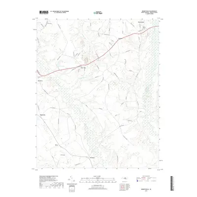
2019 Map of Bonnetsville
USGS Topo · Published 2019About this map
Roseboro sits at the western edge of this Sampson County landscape, where the Roseboro Hwy cuts a straight path through the rural interior toward Concord and Bonnetsville. The region is defined by an extensive network of blackwater drainage, including the winding Bearskin Swamp and the larger corridors of Little Coharie Cr and Great Coharie Cr. Small community centers like Snow Hill and Highsmiths anchor the agricultural uplands, while landmarks such as Hillcrest Memorial Gardens and Old Savanna reflect the local heritage. This 2019 data indicates a territory still deeply tied to its watercourses, with roads like Boykin Bridge Rd and Fleet Cooper Rd crossing numerous named branches including Turkey Br and Lockamy Mill Br. The distribution of ponds like Halls Pond and Hobbs Pond further illustrates the hydrology of the coastal plain.
Find a feature on this map
69 named features on this map. Tap any name to fly to it.
Don’t see what you’re looking for? This feature index may not catch every label — zoom into the map to look around manually.
Map Details
Editions of this 2019 Bonnetsville Map
This is the sole edition of this map. No revisions or reprints were ever made.
Other maps of this area

1909 · Coharie
USGS Topo · 1:62,500

1953 · Florence
USGS Topo · 1:250,000

1953 · Raleigh
USGS Topo · 1:250,000

1954 · Florence
USGS Topo · 1:250,000

1954 · Raleigh
USGS Topo · 1:250,000

1959 · Roseboro
USGS Topo · 1:62,500

1959 · Garland
USGS Topo · 1:62,500

1974 · Salemburg
USGS Topo · 1:24,000

1982 · Elizabethtown
USGS Topo · 1:100,000
1986 · Ingold
USGS Topo · 1:24,000