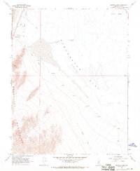
1968 Map of Bonnie Claire
USGS Topo · Published 1970About this map
Bonnie Claire serves as a lone anchor of human presence in this high desert landscape, positioned at the edge of the expansive Sarcobatus Flat. The map documents a relic industrial corridor, dominated by an extensive Old Railroad Grade that traces the valley floor, hinting at a time when ore transport was central to the region's economy. Remnants of this mining past are concrete, including an Smelting Furnace (Aban'd) and a small cluster of Graves near the settlement.
Find a feature on this map
22 named features on this map. Tap any name to fly to it.
Don’t see what you’re looking for? This feature index may not catch every label — zoom into the map to look around manually.
Map Details
Editions of this 1968 Bonnie Claire Map
2 editions found
Other maps of this area

1908 · Kawich
USGS Topo · 1:250,000

1908 · Lida
USGS Topo · 1:250,000

1913 · Lida
USGS Topo · 1:250,000

1942 · Tolicha Peak
USGS Topo · 1:125,000

1954 · Goldfield
USGS Topo · 1:250,000

1955 · Goldfield
USGS Topo · 1:250,000

1958 · Goldfield
USGS Topo · 1:250,000

1962 · Goldfield
USGS Topo · 1:250,000
1966 · Springdale
USGS Topo · 1:62,500
1967 · Bonnie Claire SE
USGS Topo · 1:24,000