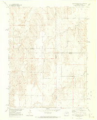
1971 Map of Bonny Reservoir SE
USGS Topo · Published 1973About this map
Beaver Creek and its tributary, Little Beaver Creek, dominate this high plains landscape along the Colorado and Kansas border in the early 1970s. The terrain is defined by a network of drainage systems, including Battle Creek, Jaqua Creek, and Bonny Creek, which carve through the arid topography. This era of the Missouri River Basin development project is reflected in the systematic mapping of section lines and township boundaries that crisscross the border. Evidence of human activity is sparse but specific, with a lone Grave and a localized Gravel Pit providing the few named markers of individual history and industry in a region primarily shaped by its waterways and political divisions.
Find a feature on this map
12 named features on this map. Tap any name to fly to it.
Don’t see what you’re looking for? This feature index may not catch every label — zoom into the map to look around manually.
Map Details
Editions of this 1971 Bonny Reservoir SE Map
2 editions found
Other maps of this area

1950 · Bonny Reservoir
USGS Topo · 1:62,500

1952 · St Francis 3
USGS Topo · 1:62,500

1954 · Limon
USGS Topo · 1:250,000

1954 · Goodland
USGS Topo · 1:250,000

1956 · Goodland
USGS Topo · 1:250,000

1957 · Limon
USGS Topo · 1:250,000

1957 · Goodland
USGS Topo · 1:250,000

1958 · Limon
USGS Topo · 1:250,000

1966 · Ruleton NW
USGS Topo · 1:24,000

1968 · Bonny Reservoir North
USGS Topo · 1:24,000