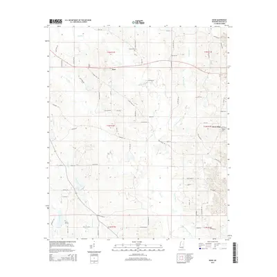
2015 Map of Boon
USGS Topo · Published 2015About this map
The settlement of Boon and the nearby community of Ellison Ridge anchor this Winston County landscape, characterized by a complex drainage network including Nanih Waiya Creek and Coopwood Creek. This survey reveals a pattern of rural settlement deeply tied to family and community history, evidenced by numerous burial grounds scattered throughout the hills. Genealogists and local historians can trace locations such as Murphy Creek Cem, New Hope Cem, and Kirk Cem. The terrain is marked by prominent ridges like Crystal Ridge, while the hydrological importance of the region is clear through the presence of Canie Creek and Town Cr. This modern edition serves as a definitive record of the road network and land divisions that have structured this part of Mississippi for generations.
Find a feature on this map
72 named features on this map. Tap any name to fly to it.
Don’t see what you’re looking for? This feature index may not catch every label — zoom into the map to look around manually.
Map Details
Editions of this 2015 Boon Map
This is the sole edition of this map. No revisions or reprints were ever made.
Other maps of this area

1953 · Meridian
USGS Topo · 1:250,000

1953 · West Point
USGS Topo · 1:250,000

1957 · Meridian
USGS Topo · 1:250,000

1958 · West Point
USGS Topo · 1:250,000

1962 · Vernon
USGS Topo · 1:24,000

1962 · Preston
USGS Topo · 1:24,000

1963 · West Point
USGS Topo · 1:250,000

1965 · Meridian
USGS Topo · 1:250,000

1972 · Louisville North
USGS Topo · 1:24,000
1972 · Noxapater
USGS Topo · 1:24,000