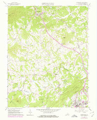
1963 Map of Boones Mill
USGS Topo · Published 1978About this map
Boones Mill serves as a primary hub in this portion of Franklin County, positioned where the Norfolk and Western railway threads through the valley of Maggodee Creek. The landscape transitions from the heights of Cahas Mountain in the northwest toward the settled areas of Wirtz and Rocky Mount in the south. The rural character is defined by a dense network of small family cemeteries and local congregations, including Brick Ch, Bethlehem Ch, and Antioch Ch. Many of these community centers are connected by the winding course of the Blackwater River and its tributaries like Little Creek and Teels Creek.
Find a feature on this map
58 named features on this map. Tap any name to fly to it.
Don’t see what you’re looking for? This feature index may not catch every label — zoom into the map to look around manually.
Map Details
Editions of this 1963 Boones Mill Map
Other maps of this area

1890 · Roanoke
USGS Topo · 1:125,000

1890 · Christiansburg
USGS Topo · 1:125,000

1891 · Roanoke
USGS Topo · 1:125,000

1925 · Rocky Mount
USGS Topo · 1:48,000

1927 · Rocky Mount
USGS Topo · 1:62,500

1944 · Rocky Mount
USGS Topo · 1:62,500

1947 · Roanoke
USGS Topo · 1:250,000

1950 · Elliston
USGS Topo · 1:62,500

1951 · Boones Mill
USGS Topo · 1:62,500

1953 · Winston-Salem
USGS Topo · 1:250,000