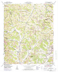
1949 Map of Booneville
USGS Topo · Published 1974About this map
The town of Lynchburg and the rural communities of southern Middle Tennessee are captured here through a detailed 1949 survey, with revisions added in the late 1960s. The geography is characterized by an intricate system of hollows and ridges, many bearing the names of early settler families such as Rob Warren Hollow, John Allen Hollow, and Sam Hart Hollow. These family names extend to the local infrastructure, seen in routes like Wiseman Road and Anderson Road.
Find a feature on this map
69 named features on this map. Tap any name to fly to it.
Don’t see what you’re looking for? This feature index may not catch every label — zoom into the map to look around manually.
Map Details
Editions of this 1949 Booneville Map
2 editions found
Other maps of this area

1936 · Booneville
USGS Topo · 1:24,000

1936 · Shelbyville
USGS Topo · 1:24,000

1936 · Cumberland Springs
USGS Topo · 1:24,000

1936 · Belleville
USGS Topo · 1:24,000

1936 · Bedford
USGS Topo · 1:24,000

1936 · Mulberry
USGS Topo · 1:24,000

1936 · Normandy
USGS Topo · 1:24,000

1936 · Fayetteville
USGS Topo · 1:24,000

1936 · Lois
USGS Topo · 1:24,000

1941 · Cumberland Springs
USGS Topo · 1:24,000