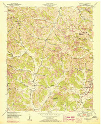
1951 Map of Booneville
USGS Topo · Published 1967About this map
Mulberry Creek and its many winding tributaries carve through the heart of this landscape, defining a rural network of homesteads and small communities south of the Bedford County line. The settlement patterns of the mid-20th century are evident in the clusterings around Booneville and the northern reaches of Lynchburg. This 1951 survey, with 1967 revisions shown in purple, reveals a countryside deeply connected to its topography, where every hollow and branch bears a family or local name, such as Sam Hart Hollow or Martin Bailey Hollow Branch. Genealogists will find significant value in the numerous small burial grounds and rural houses of worship, including Charity Cem West, Motlow Cem, and the Mt Moriah Ch. Unique landmarks like Ward Cave and Sebastian Pond provide specific points of interest for those tracing the historic character of Moore and Lincoln counties.
Find a feature on this map
62 named features on this map. Tap any name to fly to it.
Don’t see what you’re looking for? This feature index may not catch every label — zoom into the map to look around manually.
Map Details
Editions of this 1951 Booneville Map
2 editions found
Other maps of this area

1936 · Booneville
USGS Topo · 1:24,000

1936 · Shelbyville
USGS Topo · 1:24,000

1936 · Cumberland Springs
USGS Topo · 1:24,000

1936 · Belleville
USGS Topo · 1:24,000

1936 · Bedford
USGS Topo · 1:24,000

1936 · Mulberry
USGS Topo · 1:24,000

1936 · Normandy
USGS Topo · 1:24,000

1936 · Fayetteville
USGS Topo · 1:24,000

1936 · Lois
USGS Topo · 1:24,000

1941 · Cumberland Springs
USGS Topo · 1:24,000