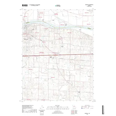
2017 Map of Boonville
USGS Topo · Published 2017About this map
The Missouri River carves a significant boundary through this region, separating Howard and Cooper counties. Along the south bank, the historic river town of Boonville serves as the primary hub, with street-level detail extending from East Water Street down to the residential expansion at Windsor Place. Local heritage is anchored at Walnut Grove Cemetery, while the northern bank is defined by the shifting alluvial landscape of Franklin Island and the Franklin Island Reach. South of the urban center, the terrain transitions into a patchwork of creek valleys and agricultural plateaus. Waterways like Petite Saline Creek and Clark Fork dictate the rural layout, where smaller communities such as Clarks Fork and Merna sit among family-named routes like Guyers Ford Drive and Nancy Potter Road. The inclusion of the Jesse Viertel Memorial Airport underscores the area's modern infrastructure within a traditional Missouri landscape.
Find a feature on this map
65 named features on this map. Tap any name to fly to it.
Don’t see what you’re looking for? This feature index may not catch every label — zoom into the map to look around manually.
Map Details
Editions of this 2017 Boonville Map
This is the sole edition of this map. No revisions or reprints were ever made.
Other maps of this area

1888 · Boonville
USGS Topo · 1:125,000

1890 · Glasgow
USGS Topo · 1:125,000

1947 · Glasgow
USGS Topo · 1:62,500

1947 · Jefferson City
USGS Topo · 1:250,000

1952 · Rocheport
USGS Topo · 1:24,000

1952 · Boonville
USGS Topo · 1:24,000

1952 · New Franklin
USGS Topo · 1:24,000
1952 · Prairie Home
USGS Topo · 1:24,000

1952 · Hilldale
USGS Topo · 1:24,000

1952 · Lone Elm
USGS Topo · 1:24,000