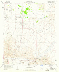
1959 Map of Borrego Sink
USGS Topo · Published 1960About this map
Borrego Valley is shown during a period of transition as desert agriculture and recreational aviation began to shape the landscape of eastern San Diego County. The map documents the layout of Borrego Springs alongside early infrastructure like the Ensign Ranch Air Strip and Borrego Air Ranch, reflecting the mid-century rise of desert tourism. To the east, the natural depression of the Borrego Sink serves as a focal point for the surrounding Badlands, while the southern portion of the quadrangle is dominated by the steep terrain of the Vallecito Mountains and Yaqui Ridge. Detailed road networks, including the Old Borrego Valley Road and numerous Jeep Trails, trace the routes through Anza-Borrego Desert State Park to landmarks such as the Tamarisk Grove Campground and the geological formation at The Narrows.
Find a feature on this map
46 named features on this map. Tap any name to fly to it.
Don’t see what you’re looking for? This feature index may not catch every label — zoom into the map to look around manually.
Map Details
Editions of this 1959 Borrego Sink Map
3 editions found
Other maps of this area

1904 · Indio
USGS Topo · 1:125,000

1931 · Vallecito
USGS Topo · 1:125,000

1939 · Borrego
USGS Topo · 1:62,500

1941 · Clark Lake
USGS Topo · 1:62,500

1942 · Barrel Spring
USGS Topo · 1:62,500

1942 · Agua Dulce
USGS Topo · 1:62,500

1942 · Clark Lake
USGS Topo · 1:62,500

1942 · Borego
USGS Topo · 1:62,500

1943 · Vallecito
USGS Topo · 1:125,000

1944 · Agua Dulce
USGS Topo · 1:62,500