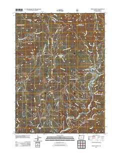
2011 Map of Bosley Butte
USGS Topo · Published 2011About this map
The Chetco River winds through the heart of this coastal mountain terrain within the Siskiyou National Forest, where high elevations are defined by a series of prominent peaks and open grasslands. This landscape is punctuated by numerous named prairies, including Wilson Prairie, Northern Prairie, and Horse Prairie, which sit alongside distinctive topographic landmarks like Bosley Butte and Buzzard Roost. The river valley features river-level locations such as Gardner Bar and Miller Bar, which contrast with the steep ridges of Panda Ridge and Palmer Butte. Significant tributaries such as Eagle Creek and the South Fork Chetco River drain the surrounding slopes, while an extensive network of forestry routes like Gardner Ridge Rd and the N Bank Chetco River Rd provide the primary access to these remote areas. This survey captures the complex drainage patterns of Wilson Creek and Nook Creek as they feed into the main river system.
Find a feature on this map
47 named features on this map. Tap any name to fly to it.
Don’t see what you’re looking for? This feature index may not catch every label — zoom into the map to look around manually.
Map Details
Editions of this 2011 Bosley Butte Map
This is the sole edition of this map. No revisions or reprints were ever made.
Other maps of this area

1954 · Coos Bay
USGS Topo · 1:250,000

1954 · Cape Ferrelo
USGS Topo · 1:62,500

1954 · Gold Beach
USGS Topo · 1:62,500

1954 · Collier Butte
USGS Topo · 1:62,500

1954 · Mt. Emily
USGS Topo · 1:62,500

1958 · Coos Bay
USGS Topo · 1:250,000

1962 · Coos Bay
USGS Topo · 1:250,000
1986 · Carpenterville
USGS Topo · 1:24,000
1986 · Brookings
USGS Topo · 1:24,000
1986 · Sundown Mtn
USGS Topo · 1:24,000