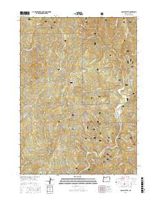
2017 Map of Bosley Butte
USGS Topo · Published 2017About this map
Siskiyou National Forest lands dominate this territory in southwestern Oregon, where the landscape is defined by the winding course of the Chetco River. The terrain is marked by numerous high-elevation openings including Looking-Glass Prairie, Yank Prairie, and Northern Prairie, reflecting a complex environment of forest and meadow. These natural clearings are interspersed with prominent peaks such as Bosley Butte and Cashner Butte, while the river corridor reveals localized geological features like Gardner Bar and Miller Bar. The presence of several named prairies alongside major drainages like the S Fork Pistol River and Panther Cr suggests a region where traditional land use and natural topography have long dictated movement through the coastal range. Forest development roads, such as Nat For Dev Rd 1407 and Nat For Dev Rd 1376 Rd, provide the primary access through this remote portion of Curry County.
Find a feature on this map
47 named features on this map. Tap any name to fly to it.
Don’t see what you’re looking for? This feature index may not catch every label — zoom into the map to look around manually.
Map Details
Editions of this 2017 Bosley Butte Map
This is the sole edition of this map. No revisions or reprints were ever made.
Other maps of this area

1954 · Coos Bay
USGS Topo · 1:250,000

1954 · Cape Ferrelo
USGS Topo · 1:62,500

1954 · Gold Beach
USGS Topo · 1:62,500

1954 · Collier Butte
USGS Topo · 1:62,500

1954 · Mt. Emily
USGS Topo · 1:62,500

1958 · Coos Bay
USGS Topo · 1:250,000

1962 · Coos Bay
USGS Topo · 1:250,000
1986 · Carpenterville
USGS Topo · 1:24,000
1986 · Brookings
USGS Topo · 1:24,000
1986 · Sundown Mtn
USGS Topo · 1:24,000