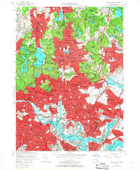
1956 Map of Boston North
USGS Topo · Published 1968About this map
Middlesex Fells Reservation and Breakheart Reservation provide extensive green space amidst the dense post-war expansion of the northern Boston suburbs. This 1950s landscape shows the transition from historic village centers like Stoneham and Melrose into a continuous metropolitan corridor. The map preserves the industrial and institutional character of the era, from the Massachusetts Soldiers Home in Chelsea to the New England Sanatorium near Spot Pond. Significant transportation infrastructure is visible, including the Boston and Maine RR lines converging at Wakefield Junction and the early footprint of Logan International Airport along Boston Harbor. Notable religious and social landmarks such as Holy Cross Cemetery and St Patricks Ch serve as focal points for local history and genealogical research in these established neighborhoods.
Find a feature on this map
170 named features on this map. Tap any name to fly to it.
Don’t see what you’re looking for? This feature index may not catch every label — zoom into the map to look around manually.
Map Details
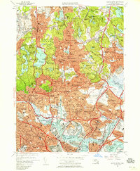
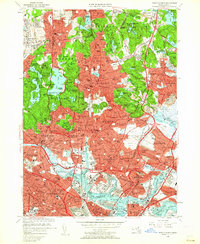
Editions of this 1956 Boston North Map
3 editions found
Other maps of this area

1886 · Lawrence
USGS Topo · 1:62,500

1888 · Lawrence
USGS Topo · 1:62,500

1888 · Salem
USGS Topo · 1:62,500

1892 · Boston Bay
USGS Topo · 1:62,500

1893 · Salem
USGS Topo · 1:62,500

1893 · Boston
USGS Topo · 1:62,500

1893 · Lawrence
USGS Topo · 1:62,500

1903 · Boston
USGS Topo · 1:62,500

1903 · Boston Bay
USGS Topo · 1:62,500

1917 · Salem
USGS Topo · 1:62,500