
1956 Map of Boston
USGS Topo · Published 1967About this map
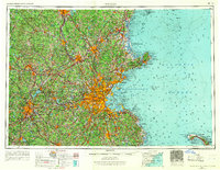
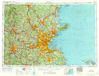
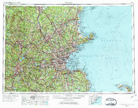
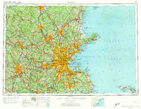
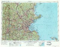
Boston and its sprawling metropolitan surroundings are captured during a mid-century period of intense postwar expansion, as evidenced by the dense yellow urban corridors stretching toward Lowell, Lawrence, and Worcester. In the harbor, the defense landscape of an earlier era remains visible through a series of island fortifications including Fort Independence, Fort Strong, and Fort Warren on Georges Island. The map provides a detailed view of the regional infrastructure that fueled this growth, from the industrial Merrimack River towns in the north to the busy rail lines of the B & M RR and NY NH & H RR. To the west, the Wachusett Reservoir and Wachusett Mountain State Reservation anchor the landscape, while the eastern coast is defined by maritime landmarks like Cape Ann Light and the newly designated Cape Cod National Seashore.
Find a feature on this map
351 named features on this map. Tap any name to fly to it.
Don’t see what you’re looking for? This feature index may not catch every label — zoom into the map to look around manually.
Map Details
Editions of this 1956 Boston Map
6 editions found
Other maps of this area

1885 · Abington
USGS Topo · 1:62,500

1885 · Duxbury
USGS Topo · 1:62,500

1885 · Worcester
USGS Topo · 1:62,500

1885 · Middleboro
USGS Topo · 1:62,500

1885 · Taunton
USGS Topo · 1:62,500

1886 · Gloucester
USGS Topo · 1:62,500

1886 · Lawrence
USGS Topo · 1:62,500

1886 · Worcester
USGS Topo · 1:62,500

1886 · Blackstone
USGS Topo · 1:62,500

1886 · Plymouth
USGS Topo · 1:62,500