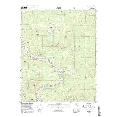
2017 Map of Boswell
USGS Topo · Published 2017About this map
The White River carves a deep, winding path through the borderlands of Izard Co and Stone Co, anchoring a landscape where river travel and rugged topography long shaped settlement patterns. Within the Ozark National Forest, the small community of Boswell sits near the river's bend, connected by the SYL Horse Trail-White River to the historic Mount Olive settlement. This area is defined by numerous family and community burial grounds, such as Palestine Cem, Old Whitehouse Cem, and Hall Mountain Cem, reflecting the deep roots of local homesteads. Significant geological markers like the Devils Backbone, Buzzard Roost, and Pilot Knob rise above the drainage networks of Piney Creek and Mill Creek, illustrating the difficult yet navigable terrain that residents have negotiated for generations.
Find a feature on this map
96 named features on this map. Tap any name to fly to it.
Don’t see what you’re looking for? This feature index may not catch every label — zoom into the map to look around manually.
Map Details
Editions of this 2017 Boswell Map
This is the sole edition of this map. No revisions or reprints were ever made.
Other maps of this area

1890 · Batesville
USGS Topo · 1:125,000

1890 · Mountain Home
USGS Topo · 1:125,000

1891 · Mountain Home
USGS Topo · 1:125,000

1891 · Batesville
USGS Topo · 1:125,000

1892 · Mountain View
USGS Topo · 1:125,000

1894 · Mountain View
USGS Topo · 1:125,000

1894 · Mountain Home
USGS Topo · 1:125,000

1945 · Harrison
USGS Topo · 1:250,000

1949 · Harrison
USGS Topo · 1:250,000

1951 · Melbourne
USGS Topo · 1:62,500