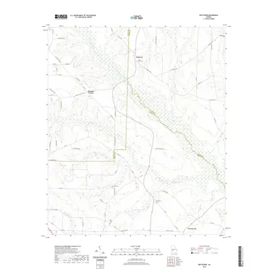
2020 Map of Bottsford
USGS Topo · Published 2020About this map
Bottsford and the rolling agricultural lands of Webster and Sumter counties are defined by a complex drainage network feeding into Kinchafoonee Creek. In this rural South Georgia landscape, the settlement pattern is historically anchored by country churches and family burial grounds, including Saint Marks Cem and Providence Cem near the northern boundary. The terrain is deeply etched by watercourses like Ty Ty Creek and Bear Creek, which meander through wetlands and bottomlands that separate the upland farms. Tracing the local road network, such as Thomas Mill Rd and Rural Hill Church Rd, reveals the enduring rural character of the area, where small communities like Pleasant Hill persist amidst the creek-split topography and long-established land lines.
Find a feature on this map
63 named features on this map. Tap any name to fly to it.
Don’t see what you’re looking for? This feature index may not catch every label — zoom into the map to look around manually.
Map Details
Editions of this 2020 Bottsford Map
This is the sole edition of this map. No revisions or reprints were ever made.
Other maps of this area

1953 · Dothan
USGS Topo · 1:250,000

1954 · Dothan
USGS Topo · 1:250,000

1955 · Dothan
USGS Topo · 1:250,000

1955 · Phenix City
USGS Topo · 1:250,000

1957 · Phenix City
USGS Topo · 1:250,000

1958 · Phenix City
USGS Topo · 1:250,000
1972 · Preston
USGS Topo · 1:24,000

1972 · Parrott
USGS Topo · 1:24,000

1972 · Shellman
USGS Topo · 1:24,000

1973 · Dawson
USGS Topo · 1:24,000