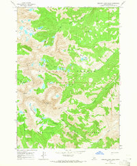
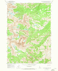
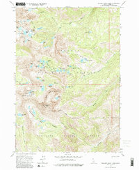
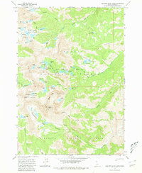
1964 Map of Boulder Chain Lakes
USGS Topo · Published 1965About this map
White Cloud Peaks dominate this high-altitude landscape in the mid-1960s, a period before this wilderness received formal federal protection. The map detail highlights an intricate network of alpine water bodies, including the namesake Boulder Chain Lakes and the Big Boulder Lakes cluster. These subalpine basins, such as Chamberlain Basin and Spring Basin, are carved into the steep slopes surrounding Castle Peak and Patterson Peak. The terrain is strictly divided by the National Forest Boundary, marking the transition between the Challis National Forest and Sawtooth National Forest. While the area is primarily defined by natural features like Little Redfish Lake and the headwaters of Big Boulder Creek, a solitary Mine symbol near the center of the sheet and the Little Boulder Creek Trail indicate the early human footprint of resource extraction and backcountry exploration in this remote Custer County interior.
Find a feature on this map
28 named features on this map. Tap any name to fly to it.
Don’t see what you’re looking for? This feature index may not catch every label — zoom into the map to look around manually.
Map Details
Editions of this 1964 Boulder Chain Lakes Map
4 editions found
Other maps of this area

1895 · Hailey
USGS Topo · 1:125,000

1897 · Hailey
USGS Topo · 1:125,000

1900 · Sawtooth
USGS Topo · 1:125,000

1919 · Custer
USGS Topo · 1:125,000

1922 · Custer
USGS Topo · 1:125,000

1929 · Bayhorse
USGS Topo · 1:125,000

1955 · Hailey
USGS Topo · 1:250,000

1957 · Challis
USGS Topo · 1:250,000

1959 · Hailey
USGS Topo · 1:250,000

1960 · Challis
USGS Topo · 1:250,000