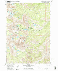
1964 Map of Boulder Chain Lakes
USGS Topo · Published 1981About this map
The White Cloud Peaks dominate this high-altitude landscape within the Challis National Forest, as it was recorded during aerial surveys in the late 1950s and field-checked in the mid-1960s. The map illustrates a dramatic alpine environment centered on the Boulder Chain Lakes, a series of high basins including Hummock Lake, Hourglass Lake, and Shelf Lake. The serrated geography is defined by sharp ridgelines like Serrate Ridge and Red Ridge, which separate deep glacial cirques and expansive meadows.
Find a feature on this map
64 named features on this map. Tap any name to fly to it.
Don’t see what you’re looking for? This feature index may not catch every label — zoom into the map to look around manually.
Map Details
Editions of this 1964 Boulder Chain Lakes Map
4 editions found
Other maps of this area

1895 · Hailey
USGS Topo · 1:125,000

1897 · Hailey
USGS Topo · 1:125,000

1900 · Sawtooth
USGS Topo · 1:125,000

1919 · Custer
USGS Topo · 1:125,000

1922 · Custer
USGS Topo · 1:125,000

1929 · Bayhorse
USGS Topo · 1:125,000

1955 · Hailey
USGS Topo · 1:250,000

1957 · Challis
USGS Topo · 1:250,000

1959 · Hailey
USGS Topo · 1:250,000

1960 · Challis
USGS Topo · 1:250,000