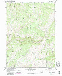
1969 Map of Boulder Mtn
USGS Topo · Published 1986About this map
Boulder Mtn and the surrounding high country of the Wasatch-Cache National Forest are defined by a complex network of springs and canyons. The drainage of Blacksmith Fork and its Left Hand Fork carve through the landscape, revealing the geological character of northern Utah. A primary indicator of early 20th-century industry is the Lucky Star Mine, situated near Cabin Spring. This era's infrastructure is further evidenced by a system of primitive routes including the Bear Pack Trail and numerous Jeep Trails that provided access to grazing lands and mineral deposits. High-altitude meadows like Squaw Flat and Elk Valley contrast with deeply cut ravines such as Steel Hollow and Ricks Canyon. Numerous water sources, from Marie Spring to the Sow Hole Spring, mark the essential hydrology for the region's livestock and wildlife management.
Find a feature on this map
62 named features on this map. Tap any name to fly to it.
Don’t see what you’re looking for? This feature index may not catch every label — zoom into the map to look around manually.
Map Details
Editions of this 1969 Boulder Mtn Map
3 editions found
Other maps of this area

1912 · Randolph
USGS Topo · 1:125,000

1914 · Logan
USGS Topo · 1:125,000

1916 · Logan
USGS Topo · 1:125,000

1949 · Boulter Mts
USGS Topo · 1:24,000

1954 · Ogden
USGS Topo · 1:250,000

1958 · Ogden
USGS Topo · 1:250,000

1960 · Ogden
USGS Topo · 1:250,000

1969 · Boulder Mtn
USGS Topo · 1:24,000
1969 · Porcupine Reservoir
USGS Topo · 1:24,000
1969 · Hardware Ranch
USGS Topo · 1:24,000