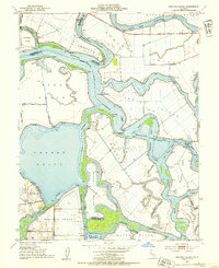
1952 Map of Bouldin Island
USGS Topo · Published 1954About this map
Franks Tract and the surrounding reclaimed delta lands are captured here in a period of complex water management and island agriculture. The map illustrates a labyrinth of sloughs, cuts, and reaches that defined transport and drainage in the early 1950s, centered on the Stockton Deep Water Channel. This major maritime artery connects the San Joaquin River through segments like Venice Reach and Mandeville Cut. Unlike more industrial riverfronts, this area is characterized by scattered rural infrastructure, including the Venice-Mandeville School and numerous pump houses that maintained the dry land of Bouldin Island and Venice Island below the surrounding water levels. The presence of numerous named points such as Prisoners Point and Webb Point highlights the navigational importance of these waterways for the local river-and-rail economy.
Find a feature on this map
57 named features on this map. Tap any name to fly to it.
Don’t see what you’re looking for? This feature index may not catch every label — zoom into the map to look around manually.
Map Details
Editions of this 1952 Bouldin Island Map
4 editions found
Other maps of this area

1894 · Lodi
USGS Topo · 1:125,000

1910 · New Hope
USGS Topo · 1:31,680

1910 · Rio Vista
USGS Topo · 1:31,680

1910 · Bouldin
USGS Topo · 1:31,680

1910 · Jersey
USGS Topo · 1:31,680

1910 · Headreach
USGS Topo · 1:31,680

1910 · Isleton
USGS Topo · 1:31,680

1913 · Woodward Island
USGS Topo · 1:31,680

1913 · Holt
USGS Topo · 1:31,680

1914 · Brentwood
USGS Topo · 1:31,680