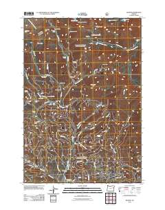
2011 Map of Bourne
USGS Topo · Published 2011About this map
The high-altitude mining landscape of the Elkhorn Mountains dominates this portion of Baker County, where the settlement of Bourne sits at the confluence of Little Cracker Creek and Silver Creek. This 2011 survey reveals an intricate network of historical extraction sites, including the North Pole Mine, Columbia Mine, and the Morning Star Mine, reflecting the intensive lode mining that once defined the Cracker Creek District. Evidence of former worker housing and seasonal base sites is visible at Cracker Camp, Silver Creek Camp, and Snell Hollow. To the south, the waters of McCully Fork feed into the Sumpter Reservoir, while higher elevations are marked by remote landmarks like Chloride Ridge and Wind Creek Peak. The map provides a detailed view of the access roads required for mountain operations, such as Cracker CR RD and Fruit Creek RD, tracing the legacy of industrial activity through a complex system of gulches and canyons.
Find a feature on this map
69 named features on this map. Tap any name to fly to it.
Don’t see what you’re looking for? This feature index may not catch every label — zoom into the map to look around manually.
Map Details
Editions of this 2011 Bourne Map
This is the sole edition of this map. No revisions or reprints were ever made.
Other maps of this area

1901 · Sumpter
USGS Topo · 1:125,000

1955 · Canyon City
USGS Topo · 1:250,000

1959 · Canyon City
USGS Topo · 1:250,000

1961 · Whitney
USGS Topo · 1:24,000
1972 · Elkhorn Peak
USGS Topo · 1:24,000

1972 · Mt. Ireland
USGS Topo · 1:24,000
1972 · Bourne
USGS Topo · 1:24,000
1972 · Phillips Lake
USGS Topo · 1:24,000
1972 · Rock Creek
USGS Topo · 1:24,000
1972 · Sumpter
USGS Topo · 1:24,000