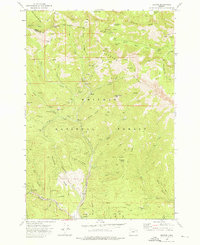
1972 Map of Bourne
USGS Topo · Published 1976About this map
The Whitman National Forest in the early 1970s reveals a landscape defined by the industrial remnants of the gold mining era. Deep within the mountains, the town of Bourne stands at the confluence of Cracker Creek and Little Cracker Creek, surrounded by dozens of identified lode claims. This map is a critical resource for understanding the scale of extraction in the Blue Mountains, showing the complex web of jeep trails and pack trails that once connected isolated workings like the Columbia Mine and the Chloride Mine to the outside world.
Find a feature on this map
71 named features on this map. Tap any name to fly to it.
Don’t see what you’re looking for? This feature index may not catch every label — zoom into the map to look around manually.
Map Details
Editions of this 1972 Bourne Map
3 editions found
Other maps of this area

1901 · Sumpter
USGS Topo · 1:125,000

1955 · Canyon City
USGS Topo · 1:250,000

1959 · Canyon City
USGS Topo · 1:250,000

1961 · Whitney
USGS Topo · 1:24,000
1972 · Elkhorn Peak
USGS Topo · 1:24,000

1972 · Mt. Ireland
USGS Topo · 1:24,000
1972 · Phillips Lake
USGS Topo · 1:24,000
1972 · Rock Creek
USGS Topo · 1:24,000
1972 · Sumpter
USGS Topo · 1:24,000
1972 · Anthony Lakes
USGS Topo · 1:24,000