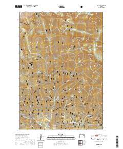
2020 Map of Bourne
USGS Topo · Published 2020About this map
The high alpine country of the Elkhorn Mountains dominates this 2020 map, revealing a landscape defined by steep drainages and glacial lakes. The settlement of Bourne sits at the confluence of Cracker Cr and Little Cracker Cr, while the larger town of Sumpter is positioned further south at the junction of McCully Fork and the Sumpter Reservoir. This area of the Whitman National Forest is crisscrossed by an extensive network of specialized routes, including the Silver Creek Snowmobile and the Spaulding Ridge Snowmobile trails, which follow the contours of the high ridges.
Find a feature on this map
70 named features on this map. Tap any name to fly to it.
Don’t see what you’re looking for? This feature index may not catch every label — zoom into the map to look around manually.
Map Details
Editions of this 2020 Bourne Map
This is the sole edition of this map. No revisions or reprints were ever made.
Other maps of this area

1901 · Sumpter
USGS Topo · 1:125,000

1955 · Canyon City
USGS Topo · 1:250,000

1959 · Canyon City
USGS Topo · 1:250,000

1961 · Whitney
USGS Topo · 1:24,000
1972 · Elkhorn Peak
USGS Topo · 1:24,000

1972 · Mt. Ireland
USGS Topo · 1:24,000
1972 · Bourne
USGS Topo · 1:24,000
1972 · Phillips Lake
USGS Topo · 1:24,000
1972 · Rock Creek
USGS Topo · 1:24,000
1972 · Sumpter
USGS Topo · 1:24,000