
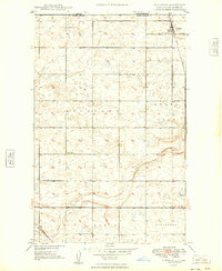
1947 Map of Bowbells NW
USGS Topo · Published 1958About this map
The Canada United States international border defines the northern edge of this Burke County landscape, where the Upper Des Lacs National Wildlife Refuge follows the serpentine path of Upper Des Lacs Lake. Mapping conducted by the Geological Survey and Bureau of Reclamation in the late 1940s reveals a prairie terrain organized by the township system, featuring the administrative districts of North Star and Minnesota. The land is punctuated by several rural educational outposts, including School No 1, School No 2, School No 3, and School No 5, which served the scattered farmsteads of the era. Natural drainage is primarily defined by Stony Run, which carves through the undulating plains toward the refuge valley. This survey captures the region as a stable agricultural frontier, where the conservation efforts of the refuge boundary meet the regulated grids of local school districts.
Find a feature on this map
11 named features on this map. Tap any name to fly to it.
Don’t see what you’re looking for? This feature index may not catch every label — zoom into the map to look around manually.
Map Details
Editions of this 1947 Bowbells NW Map
This is the sole edition of this map. No revisions or reprints were ever made.
Other maps of this area

1947 · Bowbells
USGS Topo · 1:24,000

1948 · Coteau
USGS Topo · 1:24,000

1949 · Bowbells
USGS Topo · 1:24,000

1949 · Bowbells SE
USGS Topo · 1:24,000

1949 · Bowbells NW
USGS Topo · 1:24,000

1949 · Bowbells NE
USGS Topo · 1:24,000
1949 · Northgate
USGS Topo · 1:24,000

1950 · Bowbells
USGS Topo · 1:62,500

1950 · Flaxton
USGS Topo · 1:62,500

1953 · Williston
USGS Topo · 1:250,000