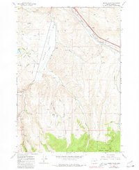
1967 Map of Bowen Valley
USGS Topo · Published 1980About this map
Bowen Valley and the surrounding high desert terrain southeast of Baker are captured in this mid-century survey, showcasing a landscape defined by the Powder River and its numerous tributaries. The settlement of Salisbury sits at a critical junction near the river, south of where the Union Pacific line cuts through the northeastern corner of the map. This rail corridor is supported by industrial infrastructure including a Weighing Station and Substation, indicating the area's role as a transit point for the region's resources.
Find a feature on this map
30 named features on this map. Tap any name to fly to it.
Don’t see what you’re looking for? This feature index may not catch every label — zoom into the map to look around manually.
Map Details
Editions of this 1967 Bowen Valley Map
3 editions found
Other maps of this area

1901 · Baker City
USGS Topo · 1:125,000

1955 · Baker
USGS Topo · 1:250,000

1959 · Baker
USGS Topo · 1:250,000

1967 · Virtue Flat
USGS Topo · 1:24,000

1967 · Encina
USGS Topo · 1:24,000

1967 · Baker
USGS Topo · 1:24,000

1967 · French Gulch
USGS Topo · 1:24,000

1967 · Dooley Mtn
USGS Topo · 1:24,000

1967 · Blue Canyon
USGS Topo · 1:24,000
1967 · Bowen Valley
USGS Topo · 1:24,000