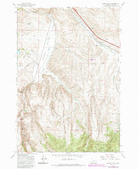
1967 Map of Bowen Valley
USGS Topo · Published 1985About this map
Salisbury and the surrounding high desert terrain near Bowen Valley are defined by the winding course of the Powder River and the industrial infrastructure of the Union Pacific railroad. Mapping from the late 1960s with 1980s updates shows a landscape where water management and transportation are paramount, evidenced by Licklider Reservoir, the Vaughn Res, and a Gaging Station along the river. The presence of the Stewart Sch suggests a once-active rural community node, while labels like Quartz and various gravel pits indicate the area's mineral and resource extraction history. Significant portions of the southern terrain are sheltered within the Whitman National Forest, where the topography becomes increasingly complex with drainage systems such as Beaver Creek and Stices Gulch. Infrastructure features including a Weighing Station and Substation near the rail line highlight the valley's role as a transit corridor for goods and energy.
Find a feature on this map
32 named features on this map. Tap any name to fly to it.
Don’t see what you’re looking for? This feature index may not catch every label — zoom into the map to look around manually.
Map Details
Editions of this 1967 Bowen Valley Map
3 editions found
Other maps of this area

1901 · Baker City
USGS Topo · 1:125,000

1955 · Baker
USGS Topo · 1:250,000

1959 · Baker
USGS Topo · 1:250,000

1967 · Virtue Flat
USGS Topo · 1:24,000

1967 · Encina
USGS Topo · 1:24,000

1967 · Baker
USGS Topo · 1:24,000

1967 · French Gulch
USGS Topo · 1:24,000

1967 · Dooley Mtn
USGS Topo · 1:24,000

1967 · Blue Canyon
USGS Topo · 1:24,000
1967 · Bowen Valley
USGS Topo · 1:24,000