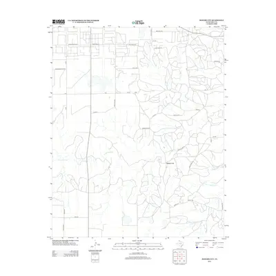
2012 Map of Bowers City
USGS Topo · Published 2012About this map
Bowers City sits at the heart of this Texas Panhandle landscape, where the agricultural grid meets the drainage network of the N Fork Red River. The map reveals a transition from the structured farm blocks of the north to the more irregular, dissected terrain of the south, carved by seasonal watercourses like Plum Cr and N Fork Grapevine Cr. Road names like Phillips Camp Rd and Carbon Black Rd offer a window into the industrial and social history of Gray County, reflecting the region's connection to petroleum and carbon black production. Local genealogists may find value in the specific naming of rural thoroughfares such as Webster Duncan Trak and Holmes Merton Rd, which preserve the names of resident families and early landholders. The presence of numerous Wind Mill Rd locations and cattle-related infrastructure like Triple Horn underscores the enduring ranching economy that defines this part of the Llano Estacado.
Find a feature on this map
33 named features on this map. Tap any name to fly to it.
Don’t see what you’re looking for? This feature index may not catch every label — zoom into the map to look around manually.
Map Details
Editions of this 2012 Bowers City Map
This is the sole edition of this map. No revisions or reprints were ever made.
Other maps of this area

1954 · Amarillo
USGS Topo · 1:250,000

1958 · Amarillo
USGS Topo · 1:250,000

1963 · Pampa
USGS Topo · 1:24,000

1965 · Lake Mc Connell
USGS Topo · 1:24,000

1966 · Grandview School
USGS Topo · 1:24,000

1966 · Kingsmill
USGS Topo · 1:24,000

1966 · Bowers City
USGS Topo · 1:24,000

1967 · Lefors
USGS Topo · 1:24,000

1967 · Hoover
USGS Topo · 1:24,000

1968 · Taylor Ranch
USGS Topo · 1:24,000