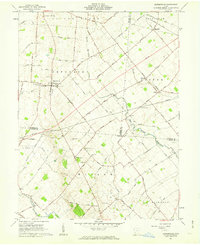
1961 Map of Bowersville
USGS Topo · Published 1963About this map
The agrarian community of Bowersville serves as a central hub for this portion of the Virginia Military District in the early 1960s. Family history is etched into the landscape through numerous small burial grounds, including Hussey Cem, Stewart Cem, and Woodlawn Cem, which are scattered among the farmsteads of Jefferson and Silver Creek townships. The local road network, including names like Baltimore and Ohio Road and Garringer Road, reflects the area's developmental history and ties to earlier transit corridors.
Find a feature on this map
93 named features on this map. Tap any name to fly to it.
Don’t see what you’re looking for? This feature index may not catch every label — zoom into the map to look around manually.
Map Details
Editions of this 1961 Bowersville Map
2 editions found
Other maps of this area

1907 · Blanchester
USGS Topo · 1:62,500

1916 · Octa
USGS Topo · 1:62,500

1917 · Xenia
USGS Topo · 1:62,500

1917 · Sabina
USGS Topo · 1:62,500

1943 · Sabina
USGS Topo · 1:62,500

1944 · Octa
USGS Topo · 1:62,500

1947 · Columbus
USGS Topo · 1:250,000

1955 · Cedarville
USGS Topo · 1:24,000

1955 · Port William
USGS Topo · 1:24,000

1961 · Columbus
USGS Topo · 1:250,000