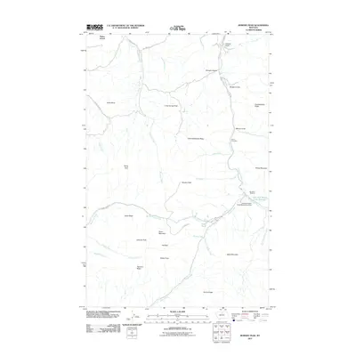
2011 Map of Bowery Peak
USGS Topo · Published 2011About this map
Parker School anchors the northwestern corner of this high-plains landscape, where the northern slopes of the Bear Paw Mountains meet the headwaters of numerous seasonal drainages. The area is defined by a dense concentration of named peaks and ridges, including Bowery Peak, Black Mountain, and Wellen Peak, which divide the watersheds of Big Sandy Creek and the West Fork Beaver Creek. The map documents a blend of rural educational infrastructure and recreational development, highlighted by the Bear Paw Ski Bowl and the Silver King Mine. Water management is central to the local geography, evidenced by the Eastfork Beaver Creek Reservation Dam and the East Fork Beaver Creek Reservoir. The presence of several ridges named with Cree or Assiniboine influence, such as Wahwahskaysiw Ridge and Owachikaysis Ridge, reflects the indigenous heritage of this Montana upland.
Find a feature on this map
45 named features on this map. Tap any name to fly to it.
Don’t see what you’re looking for? This feature index may not catch every label — zoom into the map to look around manually.
Map Details
Editions of this 2011 Bowery Peak Map
This is the sole edition of this map. No revisions or reprints were ever made.
Other maps of this area

1953 · Havre
USGS Topo · 1:250,000

1957 · Havre
USGS Topo · 1:250,000

1958 · Havre
USGS Topo · 1:250,000

1959 · Warrick
USGS Topo · 1:62,500

1959 · Laredo
USGS Topo · 1:62,500

1959 · Centennial Mountain
USGS Topo · 1:62,500

1959 · Shambo
USGS Topo · 1:62,500
1984 · Bearpaw Lake
USGS Topo · 1:24,000

1984 · Big John Butte
USGS Topo · 1:24,000
1984 · Shambo SE
USGS Topo · 1:24,000