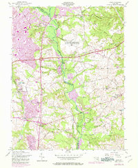
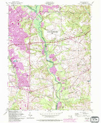
1957 Map of Bowie
USGS Topo · Published 1978About this map
Bowie and its surrounding Maryland countryside are captured here during a period of significant suburban expansion, where new residential streets and schools like Heather Hills Sch begin to press against established rural landscapes. The meandering Patuxent River serves as a natural boundary between Prince George's and Anne Arundel counties, its wetlands preserved in part by the Patuxent River Watershed Park. This landscape reveals a complex mix of uses, from the U S Military Reservation Air Force Transmitter Station to the Bowie Race Track Stables. Long-standing rural settlements such as Davidsonville and Mitchellville remain distinct, anchored by historic social centers like Sacred Heart Ch, St Pauls Ch, and Carroll Chapel. Significant sand and gravel extraction is visible along the riverbanks, particularly near Priest Bridge, marking the intersection of the region's natural resources and the material demands of mid-century infrastructure growth.
Find a feature on this map
51 named features on this map. Tap any name to fly to it.
Don’t see what you’re looking for? This feature index may not catch every label — zoom into the map to look around manually.
Map Details
Editions of this 1957 Bowie Map
5 editions found
Other maps of this area

1892 · Laurel
USGS Topo · 1:62,500

1892 · Owensville
USGS Topo · 1:62,500

1894 · Laurel
USGS Topo · 1:62,500

1894 · Relay
USGS Topo · 1:62,500

1895 · Owensville
USGS Topo · 1:62,500

1897 · Laurel
USGS Topo · 1:62,500

1899 · Patuxent
USGS Topo · 1:125,000

1900 · Washington
USGS Topo · 1:62,500

1905 · Owensville
USGS Topo · 1:62,500

1906 · Patuxent
USGS Topo · 1:125,000