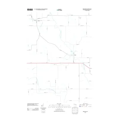
2013 Map of Bowler
USGS Topo · Published 2013About this map
Bowler sits at the intersection of local history and the flowing waters of the N Br Embarrass River in Shawano County. This 2013 survey illustrates a rural landscape defined by its riparian corridors, including the Middle Branch Embarrass River and the winding Pony Cr. The village of Tilleda is a focal point further east, situated near Tilleda Pond 53 and the North Branch Embarrass River. The network of roads such as E Railroad St and School House Rd suggests the historical importance of transit and community infrastructure in this part of Wisconsin. Further south, the path of Wi-29 provides a modern contrast to the older routes like Old 29 Rd, while family-named corridors like Zimdars Rd and Buckoski Ln offer specific points of interest for those researching local lineage and land use in the early 21st century.
Find a feature on this map
52 named features on this map. Tap any name to fly to it.
Don’t see what you’re looking for? This feature index may not catch every label — zoom into the map to look around manually.
Map Details
Editions of this 2013 Bowler Map
This is the sole edition of this map. No revisions or reprints were ever made.
Other maps of this area

1954 · Wittenberg
USGS Topo · 1:48,000

1954 · Gresham
USGS Topo · 1:48,000

1955 · Clintonville
USGS Topo · 1:48,000

1955 · Tigerton
USGS Topo · 1:48,000

1955 · Green Bay
USGS Topo · 1:250,000

1964 · Wittenberg
USGS Topo · 1:62,500

1964 · Gresham
USGS Topo · 1:62,500

1970 · Clintonville North
USGS Topo · 1:24,000
1970 · Marion
USGS Topo · 1:24,000
1970 · Tigerton
USGS Topo · 1:24,000