1969 Map of Bowling Green
USGS Topo · Published 1989About this map
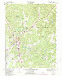
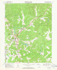
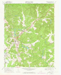
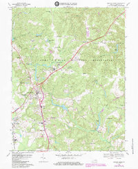
The Fort A P Hill Military Reservation dominates this 1960s landscape, illustrating the significant federal footprint in Caroline County. The map details the intersection of military training grounds and local civilian life, showing infrastructure like Airstrip No 1 and numerous Observation Towers positioned near established rural crossroads such as Acors Corner and Howards Corner. To the southwest, the town of Bowling Green serves as a clear focal point, surrounded by essential community landmarks including Lakewood Cem and Caroline High Sch. The region's transport network is anchored by the Richmond Fredericksburg and Potomac railroad passing through Milford. Numerous named ponds and creeks, such as Maracossic Creek and Elliots Pond, weave through the wooded terrain, marking the local drainage patterns that defined land use before and after the reservation's establishment.
Find a feature on this map
53 named features on this map. Tap any name to fly to it.
Don’t see what you’re looking for? This feature index may not catch every label — zoom into the map to look around manually.
Map Details
Editions of this 1969 Bowling Green Map
4 editions found
Other maps of this area

1889 · Fredericksburg
USGS Topo · 1:125,000

1892 · Fredericksburg
USGS Topo · 1:125,000

1894 · Fredericksburg
USGS Topo · 1:125,000

1918 · Doswell
USGS Topo · 1:62,500

1918 · Aylett
USGS Topo · 1:62,500

1933 · Aylett
USGS Topo · 1:62,500

1942 · Bowling Green
USGS Topo · 1:31,680

1942 · Upper Zion
USGS Topo · 1:31,680

1942 · Woodford
USGS Topo · 1:31,680

1942 · Guinea
USGS Topo · 1:31,680