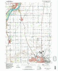
1994 Map of Bowling Green North
USGS Topo · Published 1998About this map
The Maumee River corridor defines the northwestern corner of this Wood County landscape, featuring islands like Granger Island and the distinctive Roche de Boeuf. Moving south from the river settlements of Waterville and Miltonville, the terrain shifts into the highly structured agricultural grid of the Twelvemile Square Congress Lands. This area is punctuated by small rural communities and railroad junctions such as Haskins and Tontogany, where the Otsego Sch served local families.
Find a feature on this map
64 named features on this map. Tap any name to fly to it.
Don’t see what you’re looking for? This feature index may not catch every label — zoom into the map to look around manually.
Map Details
Editions of this 1994 Bowling Green North Map
This is the sole edition of this map. No revisions or reprints were ever made.
Other maps of this area

1900 · Toledo
USGS Topo · 1:62,500

1901 · Bowling Green
USGS Topo · 1:62,500

1903 · Bowling Green
USGS Topo · 1:62,500

1909 · Mc Clure
USGS Topo · 1:62,500

1911 · Swanton
USGS Topo · 1:62,500

1914 · Swanton
USGS Topo · 1:62,500

1934 · Rossford
USGS Topo · 1:24,000

1935 · Grand Rapids
USGS Topo · 1:24,000

1935 · Whitehouse
USGS Topo · 1:24,000

1935 · Maumee
USGS Topo · 1:24,000