
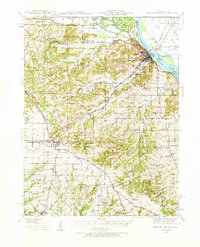
1937 Map of Bowling Green
USGS Topo · Published 1958About this map
Bowling Green serves as the focal point of this Pike County landscape during the late 1920s and 1930s, situated at the junction of the Chicago and Alton RR and U.S. Highway 61. The map reveals a highly developed agricultural and horticultural interior, most notably featuring the extensive Stark Nursery near Louisiana. The terrain transitions from the alluvial bottomlands of the Mississippi River and Salt River in the northeast to the undulating uplands of the Sugar Creek Hills.
Find a feature on this map
91 named features on this map. Tap any name to fly to it.
Don’t see what you’re looking for? This feature index may not catch every label — zoom into the map to look around manually.
Map Details
Editions of this 1937 Bowling Green Map
2 editions found
Other maps of this area

1890 · Louisiana
USGS Topo · 1:125,000

1926 · Pittsfield
USGS Topo · 1:62,500

1930 · Nebo
USGS Topo · 1:62,500

1931 · Barry
USGS Topo · 1:62,500

1932 · Hannibal
USGS Topo · 1:62,500

1934 · Nebo
USGS Topo · 1:48,000

1934 · Elsberry
USGS Topo · 1:48,000

1936 · Hannibal
USGS Topo · 1:48,000

1936 · Barry
USGS Topo · 1:48,000

1937 · Silex
USGS Topo · 1:62,500