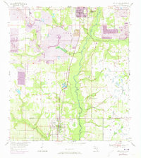
1955 Map of Bowling Green
USGS Topo · Published 1973About this map
The Peace River carves a winding path through this central Florida landscape, marking the transition between Fort Meade in the north and Bowling Green to the south. During the mid-1950s, the region's economy was heavily defined by phosphate mining, evidenced by the extensive Strip Mine operations and a large Tailings Pond that disrupt the natural drainage of McCullough Cr and Whidden Creek. The Seaboard Coast Line railroad runs parallel to the river, serving as the primary industrial artery for moving minerals and agricultural goods. Local genealogy is well-represented through the presence of several community anchors, including the Fort Meade Cem, New Hope Cem, and Mount Pisgah Ch. These sites, along with smaller landmarks like the Trailer Park and several creek crossings, provide a detailed look at the rural social structure of the Polk Co Hardee Co border area.
Find a feature on this map
25 named features on this map. Tap any name to fly to it.
Don’t see what you’re looking for? This feature index may not catch every label — zoom into the map to look around manually.
Map Details
Editions of this 1955 Bowling Green Map
4 editions found
Other maps of this area

1949 · Bradley Junction
USGS Topo · 1:24,000

1950 · Bradley Junction
USGS Topo · 1:24,000

1952 · Homeland
USGS Topo · 1:24,000

1955 · Ft. Green
USGS Topo · 1:24,000

1955 · Bowling Green
USGS Topo · 1:24,000

1955 · Wauchula
USGS Topo · 1:24,000

1955 · Baird
USGS Topo · 1:24,000

1955 · Alturas
USGS Topo · 1:24,000

1956 · Bereah
USGS Topo · 1:24,000

1956 · Griffins Corner
USGS Topo · 1:24,000