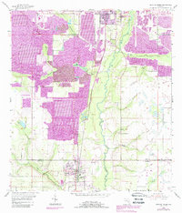
1955 Map of Bowling Green
USGS Topo · Published 1987About this map
Peace River meanders through the heart of this landscape, marking the boundary between the agricultural patterns of central Florida and an intensifying industrial footprint. While the settlements of Fort Meade and Bowling Green anchor the northern and southern reaches, much of the surrounding terrain is defined by the massive operations of the phosphate industry. Extensive Strip Mine and Reclaimed Strip Mine zones dominate the western half of the map, illustrating a landscape in active transition during the mid-20th century.
Find a feature on this map
17 named features on this map. Tap any name to fly to it.
Don’t see what you’re looking for? This feature index may not catch every label — zoom into the map to look around manually.
Map Details
Editions of this 1955 Bowling Green Map
4 editions found
Other maps of this area

1949 · Bradley Junction
USGS Topo · 1:24,000

1950 · Bradley Junction
USGS Topo · 1:24,000

1952 · Homeland
USGS Topo · 1:24,000

1955 · Ft. Green
USGS Topo · 1:24,000

1955 · Bowling Green
USGS Topo · 1:24,000

1955 · Wauchula
USGS Topo · 1:24,000

1955 · Baird
USGS Topo · 1:24,000

1955 · Alturas
USGS Topo · 1:24,000

1956 · Bereah
USGS Topo · 1:24,000

1956 · Griffins Corner
USGS Topo · 1:24,000