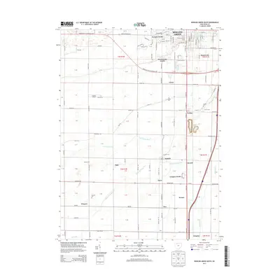
2013 Map of Bowling Green South
USGS Topo · Published 2013About this map
The southern periphery of Bowling Green transitions into a structured landscape of residential developments and agricultural holdings in the early 2010s. Modern neighborhoods such as Westgate Homes, Wintergarden Heights, and Meadowvale cluster near the city limits, while the surrounding Wood County countryside is punctuated by small, established communities including Rudolph, Portage, and Wingston. The drainage patterns of the N Br Portage River and Middle Br Portage River cross the terrain, defining the local topography alongside the historic Grand Army of the Republic Hwy. This map provides significant genealogical value through its marking of local burial grounds like Portage Cem and Bethel Cem, and cultural landmarks such as the Church Camp and Bordner Airport. The precise parcel-like grid of the Public Land Survey System reveals the systematic development of this region south of the university.
Find a feature on this map
95 named features on this map. Tap any name to fly to it.
Don’t see what you’re looking for? This feature index may not catch every label — zoom into the map to look around manually.
Map Details
Editions of this 2013 Bowling Green South Map
This is the sole edition of this map. No revisions or reprints were ever made.
Other maps of this area

1901 · Bowling Green
USGS Topo · 1:62,500

1903 · Bowling Green
USGS Topo · 1:62,500

1903 · Findlay
USGS Topo · 1:62,500

1909 · Mc Clure
USGS Topo · 1:62,500

1935 · Grand Rapids
USGS Topo · 1:24,000
1938 · Tontogany
USGS Topo · 1:31,680

1940 · Grand Rapids
USGS Topo · 1:31,680
1952 · Tontogany
USGS Topo · 1:24,000
1952 · Grand Rapids
USGS Topo · 1:24,000

1956 · Toledo
USGS Topo · 1:250,000