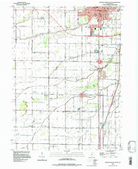
1994 Map of Bowling Green South
USGS Topo · Published 1998About this map
Bowling Green serves as the northern anchor of this survey, where the expanding urban footprint meets the agricultural landscape of the Plain. The map reveals a high concentration of educational and religious institutions that supported the surrounding rural community, from the Crim Sch and Kenwood Sch in the city to Mt Zion Ch and the South Liberty Ch further south. The transportation network is defined by the Conrail line and a grid of family-named roads like Gar Road and Digby Road, which connect the small settlements of Portage, Rudolph, and Mermill. This 1994 data reflects the persistence of these early 19th-century townships even as the North Branch Portage River and Middle Branch Portage River continue to drain the low-lying agricultural lands. The presence of the State Wildlife Production Area in the southeast corner provides a distinct contrast to the otherwise intensely cultivated terrain.
Find a feature on this map
48 named features on this map. Tap any name to fly to it.
Don’t see what you’re looking for? This feature index may not catch every label — zoom into the map to look around manually.
Map Details
Editions of this 1994 Bowling Green South Map
This is the sole edition of this map. No revisions or reprints were ever made.
Other maps of this area

1901 · Bowling Green
USGS Topo · 1:62,500

1903 · Bowling Green
USGS Topo · 1:62,500

1903 · Findlay
USGS Topo · 1:62,500

1909 · Mc Clure
USGS Topo · 1:62,500

1935 · Grand Rapids
USGS Topo · 1:24,000
1938 · Tontogany
USGS Topo · 1:31,680

1940 · Grand Rapids
USGS Topo · 1:31,680
1952 · Tontogany
USGS Topo · 1:24,000
1952 · Grand Rapids
USGS Topo · 1:24,000

1956 · Toledo
USGS Topo · 1:250,000