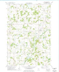
1978 Map of Bowlus
USGS Topo · Published 1978About this map
The Soo Line corridor defines the rural character of this central Minnesota landscape in the late 1970s, cutting through the townships of Elmdale and Two Rivers. The village of Bowlus sits as a primary rail-side settlement, while the smaller community of Elmdale lies to the west along Elmdale Creek. This survey captures a pocket of Morrison County characterized by its intricate drainage patterns, where the Swan River flows across the northern reaches and the multiple branches of the Two Rivers—including the North Two River, Little Two River, and South Two River—converge and meander through the central and southern sections.
Find a feature on this map
24 named features on this map. Tap any name to fly to it.
Don’t see what you’re looking for? This feature index may not catch every label — zoom into the map to look around manually.
Map Details
Editions of this 1978 Bowlus Map
This is the sole edition of this map. No revisions or reprints were ever made.
Other maps of this area

1947 · Flensburg
USGS Topo · 1:25,000

1948 · Little Falls
USGS Topo · 1:62,500

1950 · Swanville
USGS Topo · 1:62,500

1950 · Little Falls
USGS Topo · 1:62,500

1951 · Flensburg
USGS Topo · 1:25,000

1953 · Saint Cloud
USGS Topo · 1:250,000

1957 · Saint Cloud
USGS Topo · 1:250,000

1958 · Saint Cloud
USGS Topo · 1:250,000

1965 · Albany
USGS Topo · 1:24,000

1965 · St Stephen
USGS Topo · 1:24,000