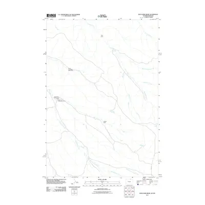
2011 Map of Box Elder Draw
USGS Topo · Published 2011About this map
Hanging Woman Creek winds through this section of the Wyoming-Montana borderlands, defining a landscape of deep draws and ephemeral prongs. In the early 21st century, this area remains characterized by its complex drainage network, where the Schoolhouse Prong and Grenell Prong feed into the larger basin of Seventysix Creek. The terrain is marked by significant topographical landmarks such as King Draw and the North Prong Box Elder Draw, reflecting the naming conventions of early ranching and surveying efforts in Sheridan County. Infrastructure is limited to a few arterial routes like Passaic Rd, which skirts the southeastern corner of the map. This survey provides a record of the watershed patterns before further development, tracing the paths of Deep Creek and the South Fork North Buffalo Creek across the high plains.
Find a feature on this map
14 named features on this map. Tap any name to fly to it.
Don’t see what you’re looking for? This feature index may not catch every label — zoom into the map to look around manually.
Map Details
Editions of this 2011 Box Elder Draw Map
This is the sole edition of this map. No revisions or reprints were ever made.
Other maps of this area

1954 · Hardin
USGS Topo · 1:250,000

1955 · Sheridan
USGS Topo · 1:250,000

1957 · Hardin
USGS Topo · 1:250,000

1958 · Hardin
USGS Topo · 1:250,000

1958 · Sheridan
USGS Topo · 1:250,000

1962 · Sheridan
USGS Topo · 1:250,000
1971 · Shuler Draw
USGS Topo · 1:24,000
1971 · Roundup Draw
USGS Topo · 1:24,000

1971 · Cabin Creek NW
USGS Topo · 1:24,000

1971 · Gardner Gulch
USGS Topo · 1:24,000