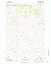
1971 Map of Box Elder Draw
USGS Topo · Published 1975About this map
The Montana and Wyoming state line bisects this 1971 topographical survey, cutting across a landscape defined by an intricate network of seasonal drainages. The drainage patterns here are particularly complex, with Hanging Woman Creek and its many tributaries, including Middle Prong Hanging Woman Creek, carving out the southwestern portion of the map. The naming of features like Coal Mine Draw and Schoolhouse Prong suggests the localized presence of early ranching and resource extraction activities that once shaped life in this border region of Sheridan County and Big Horn County.
Find a feature on this map
20 named features on this map. Tap any name to fly to it.
Don’t see what you’re looking for? This feature index may not catch every label — zoom into the map to look around manually.
Map Details
Editions of this 1971 Box Elder Draw Map
2 editions found
Other maps of this area

1954 · Hardin
USGS Topo · 1:250,000

1955 · Sheridan
USGS Topo · 1:250,000

1957 · Hardin
USGS Topo · 1:250,000

1958 · Hardin
USGS Topo · 1:250,000

1958 · Sheridan
USGS Topo · 1:250,000

1962 · Sheridan
USGS Topo · 1:250,000
1971 · Shuler Draw
USGS Topo · 1:24,000
1971 · Roundup Draw
USGS Topo · 1:24,000

1971 · Cabin Creek NW
USGS Topo · 1:24,000

1971 · Gardner Gulch
USGS Topo · 1:24,000